Montenegro - the central regions.

Lake Skadar. This amazing location
attracts lots of professionals and tourists worldwide. In any respect a unique
ecological environment and a cultural-historical area on the intersection for
centuries between the Ottoman Empire and the Montenegrin struggle for gaining
and keeping a liberated and sovereign state.
Monuments as well as archaeological locations, monastery complexes and
fortifications are widely scattered all over the Skadar lake basin, and the
large number of islands carry evidence that even in the XIV and XV centuries
this area represented a significant cultural centre.

The
Montenegrin part of the lake and its surrounding area were declared a national
park in 1983.

If
you arrive from Ulcinj you will see the Albanian shores of the lake with the
town Skadar (Shkodër in Albanian language) under the wild Albanian
mountain range at a distance. From the lake flows river Bojana 41 km to the
Adriatic Sea. Lake Skadar is just 6 m above sea level. It is only 5-6 m deep in
large areas, but maximum is 60 m. With summer water
level it is 370 km², and in the winter
season 540 km².

Godinje.
From the Montenegrin Coast
there are several roads heading to Lake Skadar, even a tunnel. But the Mountain
roads through the region Crmnica offer lots of nice sceneries, like this
village Godinje. The region is well known for producing excellent wines,
especially from vranac grapes.


Large
areas of the lake are covered in White and Yellow Water Lilies, and the waters
along the shores are covered by bamboo. This bamboo is exactly what makes the
lake very desirable for the lakes large number of bird species.
+vann-kastanje)+(kasoranja)+2308042%5B1%5D.jpg)

European Water Chestnut (Trapa natans scutariensis)
(Kasoronj) is one of three species of the genus Trapa.
They are floating annual aquatic plants, growing in slow-moving
water down to 5 meters deep. They bear ornately shaped fruits, each fruit
containing a single very large seed. They
have been cultivated in China and India for at least 3,000 years for the edible seeds.
But this local chestnut is among more than 25 rare and endangered species in
Lake Skadar and grows only here. What is unique with this plant is, according
to some sources that it can’t carry mature seeds if there is shortage of
rainfall during the summer, although the roots are always in the water. The
Kasoronj fruit is very tasty.
+(gul+n%C3%B8kkerose)+(%C5%BEuti+lokvanj).jpg)

Yellow Water-Lily (Nuphar lutea) (Žuti
lokvanj) is another aquatic plant growing in this shallow
water and wetlands. With
its roots in the sediment, the leaves are floating on the water surface. The
flower is followed by a green bottle-shaped fruit, containing numerous seeds. It can grow in water down to 5
metres deep. It is usually found in slightly deeper water than the White Water-Lily.


White Water-Lily (Nymphaea alba) (Bijeli lokvanj) wich also grows here. The leaves of the white
one can be up to 30 cm in diameter and they take up a spread of 150 cm per
plant. It contains active alkaloids, and is a sedative and an anti-aphrodisiac.
Although roots and stalks are used in traditional herbal medicine along with
the flower, the petals and other flower parts are the most potent. Alcohol can
be used to extract the active alkaloids, and it also boosts the sedative
effects. The root of the plant was used by monks and nuns for hundreds of years
as an anti-aphrodisiac, being crushed and mixed with wine.


Birds. Scutari Lake is a
habitat for 280 species of birds some of which are on the list of endangered
species. 73 species are nesting migrant types, 18 conventional migrants,
45 are winter guests and 12 species spend the summer for nesting
purposes. During the spring time the migration of birds on this lake is
considerable. Examples of endangered species is the Dalmatian Pelican
(Pelecanus crispus ), Great egret (Egretta alba), Black ibis (Plegadis falcinellus) and the Pygmy
cormorant (Microcarbo pygmeus).
Something that makes the lake unique is the nesting area of the Silver swan at
Swan island (Galebovom ostrvu), largest of its kind in Montenegro. Some
of the other unique species are: Wild duck (Anas platyrhynchos), Pilchard (Gavia
imme), Mountain eagle (Hieraaetus fasciatus) and Dwarf eagle (Hieraatus
pennatus). Double-crested Cormorant
(Phalacrocorax auritus) is another vulnerable bird species in this habitat,
and is very visible with a wingspan around 120 cm.

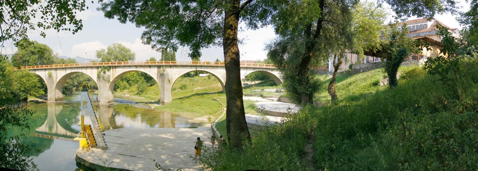
Žabljak Crnojevića (commonly only Žabljak) is a small abandoned medieval fortified town (fortress) located on the
confluence of the river river Morača in Lake Skadar. It is believed that this
fortress was founded in the tenth century during the reign of the Vojislavljević dynasty in then-known Dioclea. The fortress served as
the capital of Zeta under the Crnojević dynasty from 1466 till 1478, being the seat of Stefan and Ivan Crnojević. However, Ivan Crnojević
was forced to move the capital in 1478 when the Turks seized the town during the siege of Skadar,
holding it until the decision of the Berlin Congress in
1878 when it fell under Montenegrin administration once again after 400 years of Turkish rule. The
town has tall walls with towers, as well as one gate. Within the walls can be
found: Ivan Crnojević' court, Church of Saint George (was turned into a mosque
during Ottoman rule), housing and military facilities, a warehouse for clothes
and a water tank, most of which are preserved.

Grmozur is one of several islands
in Lake Skadar, with a fortress built in the XIX century. Among others are
Lesendro, Starčevo, Kom, Beška and Vranjina. Grmozur was where
King Nikola built a prison for political prisoners, long known also as the
Alcatraz of Montenegro.


Virpazar with a population of 337
(2003) is a fishing village and the trade center of the Crmince area. It
was first mentioned in 1242 by the name of Vir. During the rule of Peter
I, Vir developed more and more into a trade center.


Vir
was erected on the delta of the Crmnica and Orahovistice rivers. Since
1888, Vir has a road connecting it with Bar. And from 1908 came the railroad
with a 6 km long tunnel from here to the coast. A little later a road was build
from Virpazar to the town of Rijeka Crnojevića. The road tunnel "Sozina" (4,189 m) from Virpazar to the
coast was opened on July 13, 2005, Montenegro's national day.

Lesendro fortress is a monument over
the long lasting struggle of the Montenegrin people for independence, dating
back to the XV century when it was known as the capital of the Zeta region. It
was reconstructed in 1832, but in 1843 Oman paša conquered Lesendro and
Vranjina since when it has become abandoned.

Vranjina is an
island and a village with the same name by a delta of the river Morača. Its highest point is at 296 m, making it the highest
island in Montenegro. The island is connected to the mainland by a bridge.
The Orthodox monastery Vranjina is a well-known feature on
the island. According to the legend, the island had different name before the
monastery was built. When Ilarion Šišojević, the first metropolitan bishop of the Zetan Orthodox Metropolinate, started the construction of the monastery he
decided that the island will be named against the first bird he would notice.
It was a crow (vrana).

Vranjina town, on the shores of Lake Skadar is called
the Montenegrin Venice because of its natural settings. It is a popular fishing spot. Several fish restaurants are located on the island.
A notable local landmarks
include the so-called "house of Oso Kuka", named after an Ottoman border guard of Albanian descent who died at the
island struggling against Montenegrin forces in 1862. The daughters of King
Nicola often travelled to and stayed in the night quarters located on the
island at the time, but it has since been torn down.

Dodoši. The village Dodoši near the
river Karatuna was a long lasting natural border between Montenegro and the
Ottoman Empire.

Karuč is a small fishing village.
Due to mild climate, sheltered from the wind, Karuč was chosen by Saint
Petar Cetinjski (1747–1830) as his residence during winter months.


Rijeka
Crnojevića is a village (300
citizens) by the river with the same name. It is part of Old Royal Capital Cetinje. The Ottomans captured Žabljak Crnojevića in
1478 after they defeated the main army of Ivan Crnojević. Ivan moved his seat to
Obod (fortified by him in 1475) which was soon renamed to Rijeka Crnojevića and
became a new capital of his state.


Zeta
Plain is the fertile lowland
stretching from Lake Skadar to Podgorica. It is the biggest plains area in
Montenegro, with an average elevation around 40 m above sea level. The
name Zeta derives from "harvest" or "grain". And the plain
is really a rich farming land. And one of the most densely populated areas in
Montenegro. The largest settlement is Golubovci.

The giant vineyards of Plantaže, a Montenegrin quality wine producer, are situated in the plain, which is ideal for growing Mediterranean fruits and vegetables. Zeta Plain is also the site of the Podgorica Airport and a big Aluminium Plant.

Ćemovsko polje is a part of the area of Zetska ravnica (Plain of Zeta).

Cijevna river flows from Albania through Montenegro into Morača river south of
Podgorica and show off with the local Niagara Falls.

Dinoša Montenegro has so many distinctive landscapes and natural phenomena. One
of them is in the village of Dinoša, not far from the capital Podgorica. The
locals there have now asked the authorities to develop a park around their
ancient mulberry tree and promote it to tourists. A water vein flows under the
tree. And every year, after heavy rain, the water is pushed up through the
trunk and gushes out through a hole some distance up. The tree is more than a
hundred years old, but the phenomenon only started approx. 30 years ago. It
occurs after heavy rainfall and normally lasts only 3-4 days. Dinoša is located by Tuzi in the area of Malesia between Podgorica and
the Albanian border, an area where a large part of the Albanian minority lives.
The river Cijevna also flows here with at least 22 species of fish, including
the endemic marble trout; and reptiles and amphibians. The
area is classified as a nature conservation area.

Podgorica ("under the small hill") is the capital and largest town of Montenegro (156,169 citisens 2011). The favourable position at the confluence of the Ribnica and Morača rivers and the meeting point of the fertile Zeta Plain and Bijelopavlići Valley has encouraged this settlement. The town is close to winter ski centres in the north and seaside resorts on the Adriatic Sea.

When founded (before the 11th century), the town was called Birziminium. In the Middle Age, it was known as Ribnica. The name Podgorica was used from 1326. From 1946 to 1992, the town was named Titograd in honour of Josip Broz Tito, the former President of Yugoslavia.

Podgorica is at the crossroads of
several historically important routes, near the rivers Zeta, Morača, Cijevna, Ribnica and Sitnica, in fertile lowlands with
favourable climate. The earliest human settlements were in prehistory: the
oldest physical remains are from the late Stone Age. In the Illyrian age, the area between the Zeta and Bijelopavlići valleys
was occupied by two Illyrian tribes, the Labeates and the Docleats. The population of the settlement was
8,000–10,000, in which all core urban issues were resolved. The high population
density in this area of about 10 km was made possible by the geographical
position, favourable climate and economic conditions and by the defensive
positions that were of great importance at that time.

From
the 5th century, with the arrival of the first Slavic and Avar tribes and the beginning
of the break-up of the Roman Empire, the area bore witness of
many noteworthy events. With time, the fortifications ceased their function and
new towns were built. Slavic groups in the area were in constant war with
Byzantium and tended to establish a new state. The result was establishment of
a new settlement that was probably named after the river Ribnica on whose banks
it was built. The first mention of Ribnica is during the rule of the Serbian royal family of the Nemanjići. The importance of Ribnica
was its position as crossroads in communications with the west. In occupying
these areas, the Slavs created a new state and developed their own
culture and art, acceptable to the mediaeval church and feudal class.

The
name Podgorica was first mentioned in 1326 in a court document of the Kotor archives. The town was
economically strong. At the trade route between Republic of Dubrovnik (Ragusa) and the State of
Nemanjići (through Trebinje and Nikšić), it was well developed at
that time. As a busy crossroad, Podgorica was a vibrant regional centre of
trade and communication. This boosted its development, economic power, military
strength and strategic importance.

The Ottoman capture of Podgorica in 1474 interrupted its
economic, cultural and artistic development. Podgorica came under dominance of
the Sanjak of Skutari in 1479. The Ottomans built a large fortress in Podgorica, and the existing settlement, with its highly developed
merchant connections, became the main Ottoman defensive and attacking bastion
in the region. The fortified town, with towers, gates and defensive ramparts,
enabled the Ottomans to resist all attacks.
%5B1%5D.jpg)
The Berlin Congress in 1878 annexed Podgorica to Montenegro, marking the end of four centuries of Ottoman rule, and the beginning of a new era in the development of Podgorica and Montenegro. The town developed quickly and became a strong trade center. The first forms of capital concentration were seen. In 1904, Zetska savings bank, the first significant financial institution, was formed. It would soon grow into Podgorička bank. Roads were built to all neighbouring towns and, in 1902 a tobacco plant became Podgorica's first significant commercial company.

World War I marked the end of dynamic development for Podgorica,
by then the largest town in the newly proclaimed Kingdom of Montenegro. Podgorica
was occupied, as was the rest of the country, by Austria-Hungary from 1916 to 1918. After the liberation by the allies in 1918, a
controversial Podgorica assembly was held at Podgorica Tobacco
Monopoly building. The assembly marked the end of Montenegrin statehood, as
Montenegro was merged with Serbia and incorporated in the Kingdom of Yugoslavia. Between
the two world wars, the population of Podgorica was about 13,000.

Podgorica suffered heavily during World War II; the town was bombed more than 70 times throughout the course of the war and razed to the
ground, causing the deaths of over 4,100 people. The town was liberated on 19
December 1944. Under the name of Titograd, it became the capital of the
Socialist Republic of Montenegro on 13 July 1946. A period of great expansion
followed, the population increased dramatically, the town was heavily
industrialised, infrastructure was improved, and health, educational, and
cultural institutions were founded. The town rapidly became the commercial,
socio-economic, and cultural centre of the country. The progress halted again
when the break-up of Yugoslavia SFRY began in the 1990s. The name of Podgorica
was reinstated on 2 April 1992.

The destructive Yugoslav wars physically bypassed Montenegro, but the entire country
was greatly affected economically. A period of severe economic stagnation lasted
throughout the 1990s. The economy began to recover in the early years of the
21st century, when Podgorica began to emerge as a modern town. Following the independence referendum in May 2006, Podgorica became the official capital of
an independent state, boosting its status as a regional centre and raising its
economic prospects; until the financial crises gave a setback again from 2007. The old town still
remaining in Podgorica is completely neglected. This picture of Bulevar
Revolucije is from 1955.

Hristovog
Vaskrsenja, the Serbian orthodox Christ's Resurrection Church, the largest church in town recently erected. Podgorica is home to three main religious groups: Orthodox Christians, Sunnite Muslims and Catholic Christians. Orthodox Christian population mostly originates from
the local Montenegrin and Serb population, which accepted Orthodox Christianity in Middle
Ages after a major split during The Great Schism. They represent the major
religious group. There are various sacral objects of Eastern Orthodox churches
in the town such as St. George church which originates from 13th century.

Starodoganjska mosque is the seat of the Islamic
Community of Montenegro. The Muslim population mostly originates from local Bosniaks, as well as Albanians. There are several mosques
in Podgorica and Tuzi. The Catholic population mainly consists of
local autochthonous Albanian minority.

Sahat kula (Clock tower) one of the
very few Ottoman landmarks that survived WW2 bombings. Sahat Kula was built in
1667, by Adži-paša Osmanagić, a prominent citizen of Podgorica. According to the legend,
the clock was brought from Italy. For a long time, it was the only public clock
in the town. Around 1890, a metal cross was placed at the top of the tower.
Today, Sahat kula is an important cultural monument of Montenegro, protected by
law. The clock was renovated in January 2012, when the old mechanism was
replaced by a new digital one.


Duklja. Slightly north-west of
Podgorica lie the ruins of Doclea, a town known in Greek, pre-Roman and Roman times. Romans later "corrected"
the name to Dioclea. Duklja is
the later (South Slavic) version of that name. Doclea was the largest
settlement of the Docleatae, an Illyrian tribe. The town was founded in the first decade
of the 1st century AD. It was a large town with up to 10.000 inhabitants. After
the administrative division of the Roman Empire in 297, Diocleia became
the capital of the newly established province, Prevalis. In the 4th and the 5th
centuries, it was taken by the barbarian tribes and went into decline. At the
beginning of the 5th century, it was attacked by the Visigoths. A severe
earthquake destroyed it in 518. After rebuilding, the Slavs, who migrated to the area
of Duklja, destroyed it in 620, when it finally lost its classical character.
Even though Doclea remained the most important town in Duklja, the town was in
ruins by the 10th century. The historical ruins of the town can be seen today,
with the remains of the temple, spas, necropolises, and forum.

Medun. As described in 1614, it is
situated on a beautiful hill on a cleft in the mountainside, between two other
mountains, overlooking a very spacious valley. Medun is a settlement located
13 km northeast of Podgorica. The village houses the archaeological site
of the ancient fortified city of Medeon,
which was used throughout history until the end of the Middle Age. In the 2003
census, it had 108 inhabitants.

Medun was erected originally as a fortress, later on
as a town between 4th and 3rd centuries BC.
Well preserved walls of the
fortress were built of big blocks of trimmed stone, placed in a number of rows.
With respect to solidity and size of the construction it substantially differs
from the construction of other, less significant Illyrian towns. The necropolis
is sited north from the upper town. It originates from the Iron Age. Medun was
referred to later, in the 7th century, when the medieval fortification had been
built on the ruins of the Roman town. In 1614 it was described as a little town
on a hill, strategically situated, but badly guarded and in ruins, of which
fortification was held by 200 "very war-like people".


Danilovgrad has a population of 5,208
(2003 census). It is situated along the main route between Montenegro's two
largest cities, Podgorica and Nikšić, in the fertile valley of
the Zeta River, the Bijelopavlići Plain,
after the name of the local clan.

In
Danilovgrad there are remains of the ancient settlement Gradina. Remains can be found in
the outskirts of Danilovgrad. Gradina is also a prominent seat from the period
of the Nemanjić dynasty (1166-1371), and is believed
to be the birthplace of Prince Rastko, later known as Saint
Sava, the founder of the Serbian Orthodox Church.

Danilovgrad
was founded with the purpose of being the capital of Montenegro. Foundations
for this planned town were first laid by prince Nikola I in
1870. However, after the towns of Nikšić and Podgorica were taken from Bosnia and
Albania, respectively, during the Congress of Berlin 1878 its significance
diminished.


Monastery
Ždrebaonik is one of the places to
visit in Danilovgrad.

Adžijin bridge in village Mijokusovići by
the river Sušici.

Ostrog is a monastery of the Serbian Orthodox Church placed against an almost vertical background,
high up in the large rock of Ostroška Greda. It is a kind of miracle built by
nature and human interaction, dedicated to Saint Basil of Ostrog (Sveti
Vasilije Ostroški 1651-1671). From the monastery there is a superb view
of the Bijelopavlići Plain.
Ostrog monastery is founded by Vasilije, the Metropolitan Bishop of Hercegovina in the 17th century. He
died there in 1671 and some years later he was glorified. His body is enshrined
in a reliquary kept in the cave-church dedicated to the
Presentation of the Mother of God to the Temple.

The present-day look was given to the Monastery in
1923-1926, after a fire which had destroyed the major part of the complex.
Fortunately, the two little cave-churches were spared and they are the key
areas of the monument. The frescoes
in the Church of the Presentation were created towards the end of the 17th
century. The other church, dedicated to the Holy Cross, is placed within a cave
on the upper level of the monastery and was painted by master Radul, who successfully coped with the natural
shapes of the cave and laid the frescoes directly on the surface of the rock
and the south wall. Around the church are the monastic residences, which
together with the church building and the scenery make this monument so
beautiful and worth a visit even if you have no religious motivation.

Ostrog is one of the most frequently visited destinations on the Balkans. It is visited by
believers from all parts of the world, either individually or in groups. It
represents the meeting place of all confessions: the Orthodox, the Catholics and the Muslims. According to the stories
of pilgrims, by praying by his body, many have been cured and helped in
lessening the difficulties in their lives.


The Nikšić–Podgorica railway passes through 12 tunnels and over 9 bridges, mostly
following the Bijelopavlići Plain.
Reconstruction and electrification
are done. The speeds on this line are now between 75 and 100 km/h. The
line has 5 train stations (Nikšić, Ostrog, Danilovgrad, Spuž and Podgorica) and 7 train
halts. The reconstructed railway was officially open for passenger trains on
October 1st 2012. The line was built as a narrow gauge 760 mm
Bosnian gauge railway in 1948. It was connected
to the preexisting Nikšić–Bileća
line. In 1965, the line was
upgraded to standard gauge. Extension to Bileća was
decommissioned in 1976. The railway has primarily been used for transport of bauxite ore from the Nikšić mine
to the Podgorica Aluminium Plant. Chronic lack of funds for maintenance resulted
in operating speeds being reduced to 30 km/h and end of passenger service
in 1992. Passenger service was reintroduced in 2012. In 2006, thorough
reconstruction and electrification of
the line begun, with consortium of Czech companies undertaking the
construction works. The reconstruction was scheduled to be completed in 2009,
but was completed only in 2012, due to funding problems.


Nikšić is a town with 57.000
inhabitants (2011) located at the foot of Mount Trebjesa.
It is an important industrial, cultural, and educational center. The first
settlement in the area of modern-day Nikšić is thought to be formed in the 4th
century, as a Roman military camp. The camp was probably founded on the site of
the previous Illyrian tribal settlement. The camp and the settlement
were known as Anagastum
throughout the Middle Age.

The settlement got its Slavic name of Onogošt during the migrations of the Slavs into the area. During the early Slavic state of Duklja, Onogošt was mentioned
as one of the župas (administrative divisions) within Podgorje area. Along with the rest of Duklja, Nikšić became a part of the serb state Rascia in 9th
century. With the dissolution of Rascia, Nikšić came under the rule of Kingdom of Bosnia in 1373, and was under the rule of Kosača family of Hercegovina from 1448 until Hercegovina fell to the Ottomans.

Ottoman Empire took hold of Nikšić in
1455, and it stayed under control of the Turks for more than four hundred
years, as a part of Hercegovina Province. During the later years of Ottoman occupation,
Nikšić served as a significant fortified military stronghold. It was liberated
by Montenegrins in
1877, under the command of Duke Mašo Vrbica. After the liberation, the
small Ottoman hamlet began to transform into a modern urban settlement. The
first urban plan was adopted in 1883, commissioned by Prince Nikola,
and designed by Croatian architect Josip Slade. Development of Nikšić is based on the guidelines
of 1883 plan to this day. Simultaneously with urban development, cultural and
economical expansion followed after inclusion of Nikšić into Montenegro.

Although
the town was not devastated in World Wars as much as Podgorica, all development and
growth were halted. After the liberation from German occupation in 1944, the
most dynamic growth of Nikšić followed. The population was increased tenfold,
and Nikšić became the heart of Montenegrin industrial complex.


Trg Slobode
(Freedom Square) and Prince (later king) Nikola.
,+38552370.jpg)
The
National Museum of Montenegro (former Palace of King Nikola I) next to the Orthodox
church.


During
the SFR Yugoslavia era, the town flourished, as steel and iron works (Nikšićka Željezara steel plant), bauxite mines, electricity
production, brewery (Nikšićka
Pivara) and wood processing industries were set up in
and around the town. However,
as a mainly industrial town, Nikšić was hit hard during the severe economic
stagnation and decline of the industries throughout Montenegro during the
1990s, with Yugoslav Wars raging in the region. Some
of the industries recovered after 2000 but the heavy economic crisis now hits
the town very seriously.

Onogošt, the old fortress
overlooking Nikšić is believed to be the first settlement in this area (see
Nikšić). The fortress has two parts; remains of the lower part with five towers and
the system of the upper part with
six. The whole fortress is
surrounded by walls (bedem), and it is
214m long, and in the middle part, where is
the largest, about 30m wide.


The lakes. River Zeta originates in the Nikšić field, and flows near the town
of Nikšić, before it becomes a subterranean river
south of the town. The river caused frequent flooding of the plain, until the
construction of Hydro-electric power plant Perućica in 1960. That resulted in the creation
of large artificial lakes near the town; Krupačko and Slansko.
Today, the lakes are a popular recreation and relaxation retreats for the
citizens of Nikšić.


Carev Most (Tsar
bridge) is an impressive construction where it crosses River Zeta to Nikšić.

Mostanići bridge, a roman bridge close to Nikšić in the direction of Trebinje (Bosnia
and Hercegovina) and one of the oldest in the area.

Around
Nikšić there are mountain areas with numerous attractions summer and winter.

From
Nikšić the roads are heading in all direction, Trebinje to the west, Herceg Novi to the south,
or it is heading north like here, in the direction of
Šavnik and Plužine.
That leads me to my next thread, the mountainous Northern Montenegro.