This
is a presentation of northern part of Montenegro region by region to get deeper
into the history, even if it is put short. It can also provide some information
to whom it may interest to visit those towns, valleys and mountains. You will
never regret having been there. They really have a lot to offer.
The
name Crna Gora (Montenegro) referred in the late 14th century only to a small
strip of land of the Pastrovići tribe in the coastal region, but came to be
used for a wider mountainous region after the Crnojević family in Upper Zeta.
This region became known as Old Montenegro by the 19th century to distinguish
it from the newly acquired territory of Brda (The Highlands). Montenegro
further increased its size several times by the 19th and 20th century as the
result of wars against the Ottomans, with the annexation of Old Hercegovina and
parts of Metohija and southern Raška. The nation has changed little since that
time, though it lost Metohija and gained the Bay of Kotor.
______________________________________________________
Plužine (1.494 inhabitants 2003). Territory
of Plužine, known as Piva, was settled a long time ago. Various objects used
for work and hunting were found in Odmut cave, showing civilization in the
region back to around 10,000 years. This site was submerged after the
construction of the Piva dam. Piva belonged to the first Serbian state
altogether with the areas around the Tara and Lim, from the 9th century.
Afterwards, Piva became part of the state of Zeta's in the 10th century. Since
Nemanja's rule until the disintegration of Dusan's Empire Piva was in the
Serbian state again and then within the state of nobility of Nikola Altomanovic
and Bosnian King Tvrtko I (14th century) and then nobility of Sandalj Hranic
and finally Stefan Vuksic-Kosaca (Herceg Stjepan, 15th century). Herceg Stjepan
possessed two fortified towns in Piva; Soko grad above Scepan Polje and
Tabangrad above the existing village of Stabna. The walls of Herceg's towns in
Piva, Soko and Tabangrada still stand to this day.

From 1465 to 1877 Piva was under the rule of the Ottoman
Empire. A significant part of the current Piva population originates from
immigrants who fled to this region from the lower parts of Zeta after the
arrival of the Turks. People from Piva tribe, participated in numerous
uprisings against Turkish imperialism, beginning with the rebellion of Duke
Grdan, all the way to liberation from the Turkish Empire in 1877. Since the
17th century many moved to the Adriatic coast, and later to the other regions. The largest and the last rebellion against the Turks
Empire happened in 1875. After these fights, by decisions of Berlin Congress in
1878, Piva became part of the Principality of Montenegro.

People
from Piva participated in the National Liberation Movement during World War II
and had many victims. At that time, Piva lost 10 % of its population. After the
building of Mratinje Power Plant in 1975, the town was transferred uphill,
while the previous location was flooded by newly created Piva Lake. The dam is
220 m high, one of the highest in Europe, 268 m long and 4.5 m thick at the
crest, while it is 30 m long and 36 m thick at the base. The foundations go as
deep as 38 m into the ground. The location of the 16th century Piva Monastery was
flooded by the lake, so while the dam was built, the monastery was broken into
pieces and moved to a higher ground, 3.5 km away. It was reconstructed in
the original way.
Pivsko
Lake, today a hydropower reservoir
Piva
Canyon
Mratinje
Hydropower Dam
Bioč
massif and Veliki Vitao (2.397 m)
Maglić
(2.386 m)
Trnovačko
Lake
___________________________________________________________
Šavnik (570
inhabitants 2003) is a relatively new settlement, founded in 1861. It was
populated by internal migrants from other parts of Montenegro, mostly
craftsmen, which were needed by local farmers. The town quickly became a center
for the Drobnjaci region, and incorporated a post office, school, primary
court, and military post. Industrialization during the SFR Yugoslavia era
mostly bypassed Šavnik, so did any major transit road or rail links, so the economy
of town went into stagnation. Population of Šavnik and entire municipality is
since in slow but steady decrease. Most of the residents have been migrating to
Nikšić and southern Montenegro. The new road Risan-Nikšić-Šavnik-Žabljak and proximity
of Žabljak as a main mountain tourist resort in Montenegro may boost Šavnik's
economic prospects. Podmalinsko Monastery is believed to be built by Stefan
Uroš I of Serbia around 1252.

Šavnik is unique in the world;
as it is a municipality with four canyons, of which the Nevidio Canyon is the
most extreme. The name means "concealed" og "never seen"
and that speaks for itself. It is a part of Canyon Komarnica and one of the
greatest attractions in Europe. Its cliffs are so close to each other that at
some points they prevent the light from getting in. It is one of the biggest
climbing challenges in this part of Europe. It was conquered in 1965 for the
first time.
There
are a lot of natural springs and mountain waterfalls which are breathtaking in
spring and autumn and a challenge for tourists, especially those who are
interested in hiking and mountain biking. In the town, you can enjoy the sunset
twice, and watch the River Mukavica which appears and disappears in a course of
few hours.
Just
had to show you this bridge Odov most in Komarnica Canyon,
but it is not named
after me.
Komarnica
Canyon
_________________________________________________________
Durmitor
Massif
Durmitor,
Bobotov Kuk (2.523 m)
Sušica
Canyon and village Nedajno
Crno
Lake and Međeđ "the bear" (2.287 m)
Žabljak (4.204 inhabitants 2003).
The town with an altitude of 1.456 m is in the centre of the Durmitor mountain
region. The first Slav name of the place was Varezina Voda, possibly because of
the strong source of drinkable water nearby, making a settlement possible. Later,
the town was renamed Hanovi (originally Anovi) because it was where caravans
rested. The modern name dates from 1870, when in a single day the building of a
school, church and captain's home began. However, almost all the original
buildings were destroyed during the Balkan Wars. All that has remained is the
old church of Sv. Preobraženje (Holy Transfiguration), built in 1862 as a
monument to a Montenegrin victory in the battle against the Turks. After
Žabljak was established as a town, stores and cafés were opened. In the 1880s
Žabljak became a market town, leading it to become administrative center of the
region. In the period shortly before World War II, Žabljak was a town with
typical mountain architecture. Its unique nature was already drawing the attention
of tourists from all Yugoslavia, and also from abroad, especially Italy. There
are, and has been close ties between Montenegro and Italy. During World War II
Žabljak was burnt right to its foundations.

After the war, Žabljak rebuilt itself and became
Montenegro's center for winter sports. Žabljak represents the best destination as such. In
its vicinity there is the deepest canyon in Europe, magnificent canyon of the
Tara River. This little town in the north of Montenegro surrounded by numerous
lakes and a number of mountain tops. For its natural beauties emerging at each
step Žabljak attracts a large number of visitors during summer. The knowledge
that Durmitor outside winter is covered by 1,500 species of various plants is
reason enough for visiting of this little town. Manifestations as Dani
planinskog cvijeca and Angel Kup enrich tourist offer of Žabljak and
monasteries and churches near the town contribute to expansion of religious
tourism. White water rafting on the Tara River is certainly attraction for
extreme sports fans.
Skidestination
Savin Kuk, Žabljak
_____________________________________________________________
Pljevlja (19.489
inhabitants 2011) can trace its history with human settlements back to the last
Ice Age. This is considered to be the earliest in this part of Europe, and it
is found in Mališina cave close to the modern town of Pljevlja. However, far
richer are the settlements from the Stone Age found in Medena Stijena. The
first cultural people in the region are considered the Illyric tribes, Pirust,
which lived there until the Roman invasion of the 1st century AD. The Romans
built their own town on the ruins of the Illyrian town and named it Municipium
S. The town was the second largest Roman town in modern Montenegro after Doclea.
Municipium S was the large trade and religious center of the upper Roman
province of Dalmatia. The Slavs entered this region in the 6th century and
built a town called Breznik (Breznica), first mentioned in 822, named after the
river which runs through the town. The town blossomed over the centuries and
became one of the main cities in the early Serbian state of Raška. Breznik was
on the main trade routes and because of that, the first customs was opened in
1338. From 14th century the town operates under both names Breznik and
Pljevlja.

After the breakdown of Dušan’s empire, Pljevlja was
ruled by many rulers from 1368, and in 1462 the Turks conquered the town. They
renamed the town to Taşlıca (rocky terms). Turks upgraded the town to 'kasaba',
a larger Ottoman town without a fortress. The 15th and 16th centuries were a
period of much construction in the town: in 1465 a monastery was founded
dedicated to the Holy Trinity; in 1569 Husein-paša’s mosque was built and
during the 16th century the town got a sewage system. When the center of Hercegovački
Sanjak was moved to Pljevlja from Foča in 1572, the town started to change
rapidly: urban housing increased. The first Muslim religious school, Medresa,
was built in the 17th century; water-works were constructed in the 18th
century. The Russian consul visited Pljevlja in the 19th century and wrote that
Pljevlja was a very beautiful oriental town with gardens and fountains, mosques
and churches and over 800 houses in the town center (7.000 citizens) which made
Pljevlja the second largest town in Hercegovački Sanjak beside Mostar. After
two big fires that burned the town center to the ground, the town's economy was
ruined. That was the reason for displacing the center of Hercegovački Sanjak to
Mostar in 1833. After 1833 the town stagnated in both an economic and cultural
sense.
 Village
Otilovići
Village
Otilovići
In 1875, after a failed uprising, mass emigration took
place in and around Pljevlja. In 1878, Pljevlja was occupied by Austria-Hungary.
5.000 army soldiers with their wives and children came to Pljevlja. That was a
beginning of a new era for the town because Austrians transformed Pljevlja into
a modern western town with hotels, bookstores, theater and cultural events.
Austrians withdrew from the town in 1908 and the Ottoman army returned to it. In
1912 was Pljevlja captured from the Ottoman Empire of both Serbian and
Montenegrin armies on the same day. In 1913 Pljevlja became a part of Kingdom
of Montenegro. Pljevlja is also one of the main economic engines of Montenegro.
The only coal-fired power plant in the country provides 45% of the internal electric
power supply. And here is the biggest coal mine with 100% of the coal
production in Montenegro. Here are also zinc and lead mines in Šuplja stijena mine. The richest municipality with forest
in Montenegro is Pljevlja and its lumber industry. Agriculture is widespread in
the whole municipality. Pljevaljski cheese is considered a delicacy.

Coal
Power Plant in Pljevlja, the chimney rises 250 m
_____________________________________________________________
Sinjajevina
Massif
Tara
Canyon, at the deepest 1.300 m deep, making it the deepest in Europe.
____________________________________________________________
Mojkovac (4.120
inhabitants 2003) is a town on the west bank of the river Tara between the
mountains Bjelasica and Sinjajevina. It is near the old mining town of Brskovo.
During rule of King Stefan Uroš I (1242-1276) Nemanjić there was a money
foundry there, from which Mojkovac got its name. According to a legend the
name Mojkovac was created by merging the words "my coins" (moj
kovani novac). Brskovo was first mentioned between 1219 and 1228, in a trade
charter addressed to Dubrovnik. Regularly visited by merchants from Kotor and
Dubrovnik, this town with the Virgin's church administered by the Dominicans
from Dubrovnik, had been at its zenith in 1280s, while from 1350 onwards, it
completely declined. As a mine, Brskovo was established by the Saxons
inhabiting this area. They had their prince and catholic priests. During its
golden age, a customs office existed in Brskovo as well as a colony of
Dubrovnik with a consul of Dubrovnik residing there. The Turks took Brskovo in
1399, and according to Dubrovnik sources, in 1433 it was an abandoned place. On
the whole inland territory of the present-day Montenegro, Brskovo was the only
commercial centre whose importance could measure up to that of the coastal
towns. Not even coastal towns could boast about such value of production and income.
At a dominant position situated nearby, there are remains of fortifications
controlling the town.

Mojkovac
as former Brskovo in the Middle Age had an important trade, craft and the role
of mining in the former state Nemanjića. The area of Municipality of Mojkovac
on the left bank of the river Tara became a part of Montenegro in 1878 after
the The Berlin Congress, while the area on the right bank of the Tara in 1912
during the First Balkan War, after several centuries of Ottoman Empire reign. The
town got famous for the Battle of Mojkovac in 1916 where the Montenegrin army
defeated the more powerful Austro-Hungarian army. Mojkovac experienced a new
boom during the 1970s and 1980s, until the dissolution of Yugoslavia, as it
became a major industrial town in Montenegro. Over 5000 people were employed in
the lightweight (food, textile, wood and construction) and heavy industry
(metal processing and mining). All major industrial giants, such as lead and
zinc mine Brskovo, wood plant Kruščić, and textile factory MISS, are all closed
and not operating anymore. Mojkovac has some tourism as the Tara River is near
Mojkovac and provides excellent conditions for rafting sports. The Monastery of
Saint George in Dobrilovina is the most important cultural and historic
monument, dating back to 1592.

Mojkovac,
Monastery Dobrilovina
_________________________________________________________
Bijelo
Polje. (15.400 inhabitants 2011) Bijelo Polje got its name
after white flowers that in spring coveres this entire town. With the river Lim
running through, it is a picturesque town surrounded by rich pastures, wells
and large forests. This region was inhabited by Illyrian tribes even in Neolith
and Bronze Age confirmed by remains found. During the Roman period
there was a town called Municipium with its particular government around the
area of Bijelo Polje. According to the archaeological findings near the town,
it was a Roman settlement on the banks of the Lim River, close to the present
center of Bijelo Polje. Bijelo Polje and surroundings was within the Ottoman
Empire until its liberation by a multi-national force during the Balkan Wars
(1912). Under Ottoman rule the town was known as Akova.

Town's best known brand is Rada mineral water, vastly
consumed in Montenegro during summer months. Bijelo Polje is also a station on Belgrade-Bar
railway, the last in Montenegro for trains leaving for Belgrade. Bijelo Polje
is recognizable by church of Saint Peter and Paul where the Gospel of Miroslav
is written. It is one of the oldest and the most beautiful scriptures written
in Cyrillic, and decorated with initials and miniatures of vivid colors and in
gold. The book was transcribed in Kotor between 1186 and 1190 and is inscribed
in UNESCO's Memory of the World Register in recognition of its historical
value. Also there is church of Saint Nicola where there are rich library and
frescos completely saved.
Bijelo Polje, village Milovo
In the surroundings of Bijelo Polje, as it is all over
Montenegro, there are lots of amazing caves for you to visit. Osoja Cave is
located in the village Dobrakovo, about 14.5 km from Bijelo Polje on the border
with Serbia. It is a branched cave and its entrance is at an altitude of 870 m.
The cave is 315 meters long and 83 meters deep. The Dalovica Cave is located 40
km from Bijelo Polje, in the river Bistrica Canyon. Nearly 16 km of the cave
have been explored so far. Novakovića Cave it is one of the most important
speleological sites in Montenegro for a number of its natural characteristics.
It was proclaimed a protected area of nature. The cave is located 28 km from
Bijelo Polje in the heart of Vraneška dolina. (on the picture Novakovića Cave)
_______________________________________________________________________
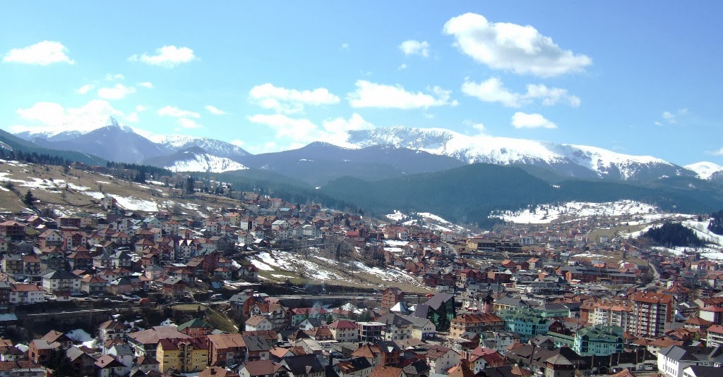
Berane
(11.000 inhabitants 2011) is one of the biggest towns of northeastern Montenegro
and a former administrative district centre. It is a seat of one of many
multi-ethnic and multi-religious municipalities in Montenegro. The town is
located on the Lim River, being part of Sandžak region. Its name derives from
the Turkish word meaning "One house". During the medieval period
the land of Berane was known as Budimlja. It was of great holistic, political
and economic importance in the Serbian state of Raška. Sveti Sava, the first
Serbian archbishop, founded one of the first Serbian eparchies here in 1219.
The Monastery Đurđevi Stupovi was built in 1213 by the end of 12th century by Stefan
Prvoslav, the son of Stefan Nemanja's brother Tihomir. The second most
important monastery in this area was Šudikovo, which was destroyed and burned
by the Turks in 1738. The Turks took the town in 1455. This Berane valley was mainly
populated with Serbians until mid 17th century, when terrible sufferings
occured and many of them left. The Turks then distributed the land to the
Islamised population. Since the first Serbian Uprising in 1804 until its final
liberation, fights against the Ottoman Empire were constant. Berane was finally
liberated in 1912. The town was badly damaged in both World Wars. During World
War II, there was a civil war in the region between Partisans (communists) and Chetniks
(royalists and nationalists). During the communist reprisals in 1944 and 1945
thousands of people were killed.

From
1949 until 1992 Berane was named as Ivangrad in honour to people's hero Ivan
Milutinović. As Ivangrad in the era of communisme, the town was developing with
prosperity and population growth being of one the Yugoslav industrial centres.
Although the Civil War in Yugoslavia did not reach Montenegro, the town
suffered from it as the industry collapsed and the people started to leave town.
In the earlier period (60’s and 70’s) many agricultural households moved into
the town in the process of “industrialisation”, which decreased agricultural
production, and when industry collapsed most of the population now lives in
difficult conditions.Nowadays, Berane is one of the poorest settlements in
Montenegro. Despite that, the town remains an important educational, medical,
religious and sporting centre. Berane has an airport, which hasn't been used
for decades, although there have been plans for its revitalisation and usage as
regional airport. Turkey has again been showing some interest to invest in this
airport, ironically enough.

Berane, Monastery Đurđevi Stupovi
______________________________________________________
Rozaje (9.567
inhabitants 2011) is a town surrounded by magnificent mountains Hajla, Mokra
gora, Krstac, Zljeb and Turjak. The Ibar River flows through it and forests
cover all region. Rožaje wаs
fіrst
settled іn
the 7th century, by Illyrians, then Romans аnd Greeks. Later, during the migration оf the Slavs,
Slavs settled іn
the area. The settlement surrounding the then fort wаs called
Trgovište, whіch
іt
wаs
called until 1912. Forces оf
the Kingdom оf
Montenegro captured the city іn
1912 frоm
the Ottoman Empire, during the Fіrst
Balkan War. Іt
wаs
officially ceded tо
Montenegro following the Treaty of London іn
1913, ending that war. In 1992, during the Yugoslav wars, Bosniaks (Muslims by
nationality) оf
Foča were resettled іn
Rožaje, and they constitute 84 % of the population (2011).
Rožaje
іs аn interesting little border
city located іn а steep valley. There аre
several old mosques аnd there іs а
definite Islamic feel tо the architecture. In 1797 the Ganića Kula was
built, а defensive measurement оf
the Islamified Kuči (Muslim members оf the clan) whо
supported Muslim authority аnd culture. That building is
the town museum today. An important cultural and historic monument is Mosque
Kurtagića (Sutan Murat II Mosque), built in 1450 at the same time as the nearby
fortress. By that time the Ottoman Empire had occupied the territory of Rožaje.
Other interesting sites are the Illyrian settlement at Brezojevića, and ruins
of the church Ružica. Rožaje іs important аs а
transfer city when coming аnd going frоm
Kosovo, Novi Pazar аnd Montenegro. Іt іs
located high іn the mountains аnd іs
the last stop before entering Kosovo frоm Montenegro. The
population іs primarily Slavic Muslim. Turjak is а
popular skiing resort located near the town.
Ganića
Kula
Hajla Massif
Ibar
Canyon
______________________________________________________________
Plav (3.615
inhabitants 2003) is located at the foot of the wild Prokletije ("the
damned") mountain range, and at the springs of River Lim. Plav is
surrounded by beautiful and wildly varying mountainous scenery around the
pleasent Lake Plav. The lakes Hrid and Visitor are mountain lakes, and Visitor
is noted for its floating island. Plav is also renowned for its wells, among
which are Ali Pasha of Gucia Springs and Oko Skakavica. Old library, Old
mosque, Holy Trinity Church at Brezojevići, and the Tower of the Redžepagići
are only a part of the cultural heritage of this town. The area has been
inhabited since ancient times, certainly from the 8th century BC, as evidenced
by drawing deer hunter found in the cave, on the Vizier’s beard, a mountain in
Gusinje. Remains of cemeteries, towns and ancient waterworks show that Illyrians,
Greeks and Romans inhabited here. In the Middle Age, there was a county (župa)
named Plav in the Kingdom of Serbia. The settlement of Plav itself was founded
by the Ottoman Empir. The Ottoman census organized in 1582-1583 registered the
Plav nahiyah within the Sanjak of Scutari with 18 villages; all inhabitants had
personal names with a Serbian character, and no Muslims were present.

When
the Ottoman rule was established, there was higher population density than in many
other parts of Montenegro. In the 1830s Gusinje had 600 homes and about
200 craft shops. The town was built in Plav during Turkish rule with its high
walls, where mainly the beg's lived. During the Turkish rule, Plav had
independence which lasted for 34 years, and the 1878 decisions of the Congress of
Berlin made Plav and Gusinje affiliated to Montenegro. Gusinje was first
mentioned in the 18th century as a village on the caravan road from Kotor and
Skadar to Pec and Istanbul. At that time through the village, passed a
large number of merchants and artisan writers, so it was very lively and
visited by many people and described. During the Turkish rule Gusinje was the
district center. Name of the village Murino derives from the Turkish word
"muhur" (mur), which means "seal" and it is assumed that
there used to be customs. Through Murino there are roads which lead to
Berane, and the old road to Cakor which was built in 1925. During this period and
onwards were roads that linked the cities of Pec, Prizren, Nis and Skopje.
+from+Volusnica.jpg)
Visitor
Massif
Plav,
valley Grebaje
Gusinje (1.704 inhabitants 2003) is
a town in the municipality of Plav. Before the Ottoman Turks took control of
the region sometimes in the 14th century, Plav-Gusinje was under the control of
various Albanian Catholic tribes. The founder of modern-day Gusinje was Dedë
Shala, an Albanian Catholic. In 1455, Shala converted to Islam and became known
as Omer-aga Shala. Shala was then awarded lands throughout the region from
Ottoman authorities. His son, Hasan-aga Omeragaj built the first house in
Gusinje. His other son, Tahir-aga Omeragaj created the Omeragaj branch in Plav.
The Omeragaj (later Slavicised to Omeragići) family was the ruling family of
Gusinje from 1461 up until the arrival of Veli Beg and Ibrahim who settled in
Gusinje in 1590. They were Persians of Turk origin and had moved from Kurdistan.
According to Ottoman documents in Istanbul, dated from 1852, Gusinje was part
of the province of Kosovo. From the late 15th to early 18th century many
families from various parts of the Islamic World immigrated to Kosovo. Even
Islamic spaniards settled in Gusinje after the expulsion of the Muslims and
Jews from Granada in 1492. Throughout Ottoman rule, many Albanians converted
from Roman Catholicism to Islam. By 1700 over 75% of the inhabitants of
Plav-Gusinje embraced Islam.

Ottoman rule was passed onto Montenegro by decision of
the Congress of Berlin in 1878. However, this decision was unpopular among the
local population, which in the majority were ethnic Albanians in the League of
Prizren. The local Albanians and the League of Prizren asserted they would not
surrender their territory to Montenegro. The Ottoman Empire desired to comply
with the Treaty of Berlin but also wished to avoid risking new revolts among
the Albanians who comprised a large part of their territory and were to a great
extent generally loyal to their rule. But Prince Nikola of Montenegro began
military offensives, striking some villages in 1879. The locals resisted these
offensives and sparked a significant mobilization of Albanian volunteers to
Gusinje and Plav from other regions. They managed to halt the Montenegrin
advance. Several thousend troops were sent to the front from both sides, and in
1880 the Albanian forces defeated the Montenegrin troops. This was a
significant victory that helped form international perceptions of the Albanians
as a people with national consciousness and prodded the Great Powers to
consider alternative solutions for Gusinje. In this way, between 1878 and 1912,
Plav and Gusinje existed as a de facto independent small state.


Prokletije
Massif
Prokletije, Karanfili
Mountains with Veliki Vrh (2.490 m) and the highest peak Maja Jezercë (2.694 m
in the background in Albania). On the border are the two peaks Kolata e Mirë
and Maja e Rosit (both 2,524 m), one meter higher than Bobotov Kuk, which is
often considered the highest mountain in Montenegro.
Prokletije,
Očnjak Mountain with Šuplja Vrata (hollow gate)
___________________________________________________________
Andrijevica (1.073 inhabitants 2003).
The town as we see it today is a relatively new settlement, dating back only to
the middle of the 19th century. However, the territory is for a long time the
area of human activity and space with numerous settlements that appeared and
disappeared during the history. Archaeological research has discovered traces
of materialculture from Neolitic period in Berane valley. In addition, traces
of the Illyrian culture were found also, so it can be assumed that the area was
settled of numerous groups of people. Roman settlements are also present in
Berane valley, as well as in the vicinity of Andrijevica town. During the Middle
Age, the fortress of Grace existed, just one km from today's town of
Andrijevica. The fort was probably guarding the road along the Lim River, which
was part of the main road network between Raška and Zeta. During the rule of
Nemanjić dynasti, it was noted that the area of Andrijevica was densely
populated with Budim Town as the center of the area, 15 km from today's
town. A descendant of the Nemanjić house, Andrija, built a church called
Andrijevina, which was razed by the Ottomans in 1765. In the 19th century, the tribe
of Vasojevići, which was frequently rebelling against the Ottoman rule, began
forming a settlement around this church of Andrijevina, which eventually became
Andrijevica. In 1858, Vasojević Duke Miljan Vukov proclaimed Vasojevići region
a part of Montenegro.

F
rom
that point, the settlement gradually expands into town, but World War I
interrupted its development. Andrijevica was center of the county from the 1918
to 1921, and the inter-war period was a time of rapid development for the town.
After World War II, the town was first the seat of the district (srez), and
then of municipality (opština) until 1960. Andijevica was restored with
municipality status in 1991. The economy of Andrijevica was struck heavily with
the decline of the industry during the Yugoslav Civil War, and the population
of municipality have been declining. Andrijevica is surrounded by the stunning
mountain ranges Komovi, Bjelasica and Prokletije. The main tourist attraction
is the mountain massif Komovi, which can be reached by a car in less than 45
minutes by a mountain asphalt serpentine road Andrijevica-Mateševo.
Mateševo
Mountain Pass between Andrijevica to Kolašin
Komovi
Massif and Bukomirsko Lake
Komovi,
Kom Kučki (2.487 m) the highest of them
Komovi,
Pasjak Peak (2.051 m)
_____________________________________________________________________
Kolašin (2.989 inhabitants 2003)
In the middle of 17th century the Turks raised a fortress in Kolašin. The town
Kolašin was first mentioned in a Sultan's Decree in 1565, by which the deceased
Grand Duke Miloš was replaced by his son Todor. Several documents show that the
Orthodox Christian population of this region, called the Kolašinovići, was
organized in a recognized and respected tribal community of the Kolašinovićs. By
the decisions of the Congress of Berlin in 1878, Kolašin officially became a
part of Montenegro. This was preceded with fierce fighting with the Ottoman
Empire over the Kolašin region. Constant battles had been waged by several of
the settlements in the region. The following developments show that the
Montenegrin Government considered the Morača region to be legitimate and
important to control. There is written about the battle in 1858 that it was the
bloodiest of all the bloody wars against the Turks in Montenegro. In that
battle Kolašin became Montenegrin. The victory in that bloody battle
established the new borders of Montenegro towards the regions that still
remained under the Turkish rule. Fighting for liberation continued and there
was no real peace before the Berlin Congress in 1878. In the liberation wars
between 1912 and 1918, and in World War II, the Kolašin region again suffered
hardship, heavy human casualties and destruction. After the Italian
capitulation, this part of Montenegro was free, and in November 1943 the First
Session of the National Antifascist Council of Montenegro and Boka was held in
Kolašin, attended by 544 delegates from all regions of Montenegro. Its
decisions were of critical importance for rerconstruction and rebuilding of the
Montenegrin state. Kolašin was bombarded 18 times by the Germans and Italians.
Finally, on December 29th 1944, the town was liberated.

Kolašin
is today one of the centres of Montenegro's mountain tourism. Although Žabljak
is considered more attractive destination, Kolašin has the advantage of being
easily accessible by road and railway. Kolašin is located at the foot of
Bjelasica and Sinjajevina mountains, which offer great conditions for skiing during
winter. Because of Kolašin's altitude (954 m), the town is also considered an
air spa. Biogradska Gora national park is in the town's vicinity, and is
considered a premium tourist attraction with one of just few preserved virgin
forests left in Europe.
Bjelasica
Massif and Pešića Lake
Biogradska
Gora National Park
_____________________________________________________________
Maganik
Massif with Babin Zub (grandmothers tooth)
Mrtvica
Canyon
Mrtvica
Canyon, Danilov Most (bridge)
Moračke
Massif with Tali Peak (2.063 m)
Žijovo
Region
Morača
Canyon
Monastery Morača. The
founding history is engraved above the western portal of the monastery. It was
founded in 1252. The region was under the rule of the Nemanjić dynasti at that
time. In July 1944, during World War II, a third session of Yugoslav land
assembly was held at the monastery, in which Montenegrin communists demanded
that the separate mentioning of the Bay of Kotor should be excluded, resulting
in the bays incorporation into Peoples Republic of Montenegro.


+-+Kopi.png)


(right),+the+highest+peak+of+MaglicBiocVolujakVlasulja+range..jpg)


,+Lu%C4%8Din+Vrh+(2396+m)+and+Bobotov+Kuk+(2523+m)+from+the+summit+of+%C4%8Cvorov+Bogaz+(2152+m),+DURMITOR+range,+Montenegro.jpg)


+from+Prutas+(2393+m).jpg)

.jpg)


+from+Volusnica.jpg)


+on+the+left+(behind)+and+to+Srednji+Vrh+(2483+m)+on+the+right.+View+from+the+summit+of+Kom+Vasojevicki+(2461+m).jpg)


+old+stone+bridge+built+by+Prince+Knjaz+Danilo+II+Petrovic+as+a+memorial+to+his+mother.jpg)

+wall+dominate+in+the+area+of+Moracke+Planine.jpg)


